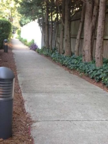
Trolley Walk
(ca. 1913)
A unique remnant of Charlotte’s streetcar system, the Trolley Walk illustrates how that transportation technology influenced Charlotte’s early 20th century residential development.
2100 Blocks of East 5th, 7th, and 8th Streets and Greenway Avenue, Charlotte, NC 28204
The Trolley Walk in the Elizabeth neighborhood – a concrete slab sidewalk wide enough to accommodate two lanes of pedestrian traffic that connects East Fifth and Seventh Streets – is one of the few remnants of the streetcar system that spurred Charlotte’s suburban development during the early twentieth century. Extending through the center of two city blocks and connecting with public sidewalks along East Seventh Street and Greenway Avenue, the Trolley Walk was constructed as an amenity for residents of the Rosemont subdivision.
Property Quick Links
As Charlotte’s second streetcar suburb, the early twentieth century development of Elizabeth occurred quickly but incrementally in five stages. The first development, Highland Park, began in 1891 along Elizabeth Avenue, near the present location of Central Piedmont Community College. It was serviced by the city’s horse-drawn and mule-drawn streetcar service that dated back to 1887. The replacement electric trolley network began service in March 1891 and expanded over the next 25 years, facilitating residential development opportunities beyond the historical confines of Charlotte’s center city. By 1903, the East Trade Street electric streetcar line extended to Highland Park’s Elizabeth College. Further extensions along Elizabeth Avenue, Hawthorne Lane, and Seventh Street expedited residential subdivision development as more reliable and frequent streetcar service provided easy access to the commercial and business centers downtown. The Elizabeth neighborhood quickly added the Piedmont Park (1900), Oakhurst (1903), and Elizabeth Heights (1904) subdivisions.
Development plans for Rosemont, Elizabeth’s final phase and the area farthest from downtown, included the Trolley Walk as an amenity unique to the subdivision. The Trolley Walk allowed all Rosemont lots to be sited within a two-block walk of the streetcar, a convenience that created higher values for side street properties not located directly on the streetcar route. The developer intended the Trolley Walk to be a publicly owned right-of-way, but the city never accepted ownership, leaving the walk to the ownership of the individual adjacent property owners.
The Trolley Walk extends from the west side of East Seventh Street, where Clarice Avenue and East Seventh Street meet, through the middle of the block to Greenway Avenue. From the west side of Greenway Avenue, the walk runs to the east side of East Fifth Street where the path ends. Along its course, the Trolley Walk is bounded by early twentieth century residential development, including apartment houses, two-unit dwellings, and single-family houses.
The Trolley Walk specifically illustrates the importance of the streetcar in determining Charlotte’s residential development patterns in the early twentieth century. In an area that has undergone tremendous alteration, the Trolley Walk and the early twentieth properties surrounding the pathway remain as remarkably intact and vivid illustrations of early twentieth-century middle-class suburban construction.

